
Drone Aerial Photo
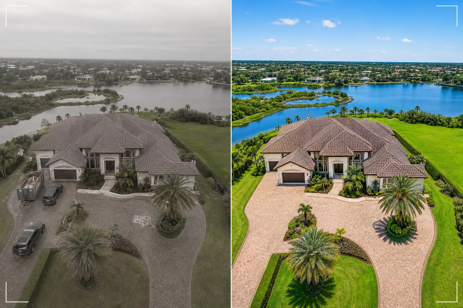
Transform drone footage stills into stunning aerial images. This template replaces overcast skies, enhances landscape color vibrancy, removes unwanted vehicles and construction equipment, sharpens property details visible from above, and corrects the flat color profile common in drone camera footage.
Try this template freeReal Estate template preview
What this template does
Processes drone aerial photos for real estate listings, property marketing, land surveys, and architectural documentation. Drone cameras typically shoot with a flat color profile designed for video color grading, which makes still photos look desaturated and hazy compared to dedicated camera stills. This template applies targeted color correction that restores vibrant landscape greens, saturated roof tiles, and clear blue waterways from the flat drone output. Magic Eraser removes vehicles, construction equipment, dumpsters, and other temporary objects visible from above that make a property look less appealing. AI Enhance sharpens building edges, landscaping details, and property features that drone altitude and atmospheric haze tend to soften.
Template settings
| Sky replacement | Clear blue sky or golden hour (matching ground light direction) |
| Landscape color | Vibrant green grass, saturated foliage, clear water tones |
| Haze removal | Atmospheric haze and drone altitude softness correction |
| Object removal | Remove vehicles, dumpsters, and construction equipment |
| Output resolution | 5000px long edge (print and large-format display ready) |
How to use this template
Upload your drone photo
Upload a still from your drone — DJI, Autel, Skydio, or any platform. The template handles both raw DNG files and compressed JPEG output. For best results, shoot at the lowest available altitude that captures the full property and its surroundings, as closer shots have more detail for the AI to enhance.
Sky and color correction
Overcast or hazy skies are replaced with clear blue or golden hour alternatives that match the light direction on the ground below. The flat drone color profile is corrected to produce rich landscape greens, warm building tones, and clear blue water if present. Atmospheric haze is removed to restore crispness.
Remove unwanted objects
Magic Eraser removes vehicles in driveways and on streets, construction dumpsters, portable toilets, equipment, and any temporary objects visible from above. The AI reconstructs the driveway, lawn, road surface, or rooftop behind removed objects using surrounding context.
Export for listing or presentation
Download at 5000px long edge for large-format prints and presentation boards, or at web-optimized dimensions for MLS listings and property websites. The enhanced aerial perspective provides the comprehensive property overview that ground-level photos cannot achieve.
Pro tips for best results
- ✓Fly during golden hour (the hour after sunrise or before sunset) for the most dramatic lighting. Low-angle sunlight creates long shadows that reveal terrain contour and add dimension to buildings. The template can enhance any time of day, but golden hour aerials are the most visually striking starting point.
- ✓Capture both a high-altitude overview (showing the full property and neighborhood context) and a low-altitude detail shot (showing the building, landscaping, and outdoor living spaces). Process both through the template for a complete aerial perspective.
- ✓For waterfront properties, time your flight with calm water conditions. Glassy water produces cleaner reflections and more appealing blue tones that the template enhances. Choppy water can look cluttered from above and is harder to enhance to a magazine-quality finish.
Common questions
Can this fix drone photos taken on overcast days?
+
Yes. Overcast sky replacement is one of the most impactful improvements. The template replaces the flat white sky with a natural blue sky whose lighting direction matches the soft, even illumination already on the ground — which is actually advantageous because overcast light creates minimal harsh shadows on buildings.
What about high-altitude shots with atmospheric haze?
+
The template includes a dedicated haze removal step that restores contrast and color saturation lost to atmospheric haze at altitude. This is most effective for shots taken between 100–400 feet where haze is present but the subject is still close enough to retain detail.
Can I process video frames from drone footage?
+
Yes. Extract the best still frames from your 4K drone video and process them through the template. Video frames are lower resolution than dedicated still photos (8–12 MP versus 20–48 MP), so the output will be slightly less detailed, but the color correction and sky replacement are fully effective.
Aerial views that sell properties from above
Upload drone photos and get sky-enhanced, color-corrected aerial images that showcase properties at their most impressive.
Try it freeRelated templates
More real estate templates for your workflow.
Professional real estate photo template for MLS listings. HDR-like enhancement, sky replacement, clutter removal, and color correction for property photos that sell faster.
Enhance architecture exterior photos with vertical line correction, sky replacement, car and pedestrian removal, and golden hour color grading for listings and portfolios.
Transform Airbnb and vacation rental photos with room brightening, clutter removal, color correction, and wide-angle lens distortion fix for higher booking rates.
Enhance interior design portfolio photos with room brightening, clutter removal, material texture sharpening, and color-accurate rendering of finishes and fabrics.
Virtually stage empty rooms with realistic furniture, decor, and lighting. Help buyers visualize living spaces without physical staging costs.
Clean, enhance, and standardize floor plan images for real estate listings with stain removal, line sharpening, and consistent styling.