
Foto aerea con drone
Trasforma i fermi immagine delle riprese con drone in splendide immagini aeree. Questo modello sostituisce i cieli coperti, esalta la vivacità dei colori del paesaggio, rimuove veicoli e attrezzature da cantiere indesiderati, rende più nitidi i dettagli della proprietà visibili dall'alto e corregge il profilo colore piatto comune nelle riprese delle fotocamere dei droni.
Prova questo modello gratisReal Estate template preview
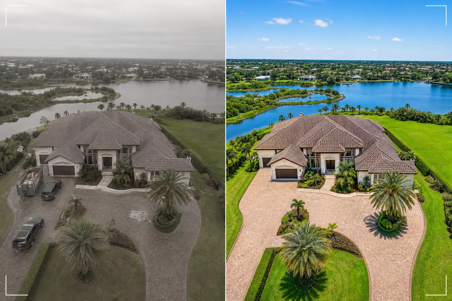
Cosa fa questo modello
Elabora foto aeree con drone per annunci immobiliari, marketing di proprietà, rilievi fondiari e documentazione architettonica. Le fotocamere dei droni in genere riprendono con un profilo colore piatto progettato per la color grading video, il che fa apparire i fermi immagine desaturati e foschi rispetto agli scatti di fotocamere dedicate. Questo modello applica una correzione colore mirata che ripristina vividi verdi del paesaggio, tegole sature e corsi d'acqua di un azzurro limpido a partire dall'output piatto del drone. Magic Eraser rimuove veicoli, attrezzature da cantiere, cassonetti e altri oggetti temporanei visibili dall'alto che rendono una proprietà meno attraente. AI Enhance rende più nitidi i bordi degli edifici, i dettagli del paesaggio e le caratteristiche della proprietà che l'altitudine del drone e la foschia atmosferica tendono ad ammorbidire.
Impostazioni del modello
| Sostituzione del cielo | Cielo azzurro limpido o ora dorata (in linea con la direzione della luce a terra) |
| Colore del paesaggio | Erba verde vivace, fogliame saturo, toni d'acqua limpidi |
| Rimozione della foschia | Correzione della foschia atmosferica e della morbidezza dovuta all'altitudine del drone |
| Rimozione di oggetti | Rimuovi veicoli, cassonetti e attrezzature da cantiere |
| Risoluzione di output | 5000px sul lato lungo (pronto per stampa e display di grande formato) |
Come usare questo modello
Carica la tua foto da drone
Carica un fermo immagine dal tuo drone — DJI, Autel, Skydio o qualsiasi piattaforma. Il modello gestisce sia i file DNG grezzi sia l'output JPEG compresso. Per risultati ottimali, scatta all'altitudine più bassa disponibile che catturi l'intera proprietà e i suoi dintorni, poiché gli scatti più ravvicinati offrono più dettagli da migliorare per l'IA.
Correzione del cielo e dei colori
I cieli coperti o foschi vengono sostituiti con alternative di cielo azzurro limpido o ora dorata che corrispondono alla direzione della luce sul terreno sottostante. Il profilo colore piatto del drone viene corretto per produrre verdi del paesaggio intensi, toni caldi degli edifici e acqua di un azzurro limpido se presente. La foschia atmosferica viene rimossa per ripristinare la nitidezza.
Rimuovi gli oggetti indesiderati
Magic Eraser rimuove veicoli nei vialetti e sulle strade, cassonetti da cantiere, bagni portatili, attrezzature e qualsiasi oggetto temporaneo visibile dall'alto. L'IA ricostruisce il vialetto, il prato, la superficie stradale o il tetto dietro gli oggetti rimossi utilizzando il contesto circostante.
Esporta per annuncio o presentazione
Scarica a 5000px sul lato lungo per stampe di grande formato e pannelli di presentazione, oppure in dimensioni ottimizzate per il web per annunci MLS e siti web immobiliari. La prospettiva aerea migliorata offre la panoramica completa della proprietà che le foto a livello del suolo non possono raggiungere.
Consigli da professionisti per risultati ottimali
- ✓Vola durante l'ora dorata (l'ora dopo l'alba o prima del tramonto) per l'illuminazione più suggestiva. La luce solare a basso angolo crea ombre lunghe che rivelano il profilo del terreno e aggiungono tridimensionalità agli edifici. Il modello può migliorare qualsiasi momento della giornata, ma le riprese aeree all'ora dorata sono il punto di partenza visivamente più d'impatto.
- ✓Cattura sia una panoramica ad alta quota (che mostri l'intera proprietà e il contesto del quartiere) sia uno scatto di dettaglio a bassa quota (che mostri l'edificio, il paesaggio e gli spazi abitativi esterni). Elabora entrambi con il modello per una prospettiva aerea completa.
- ✓Per le proprietà sul lungomare, pianifica il volo in condizioni di acqua calma. L'acqua liscia come uno specchio produce riflessi più puliti e toni azzurri più attraenti che il modello esalta. L'acqua mossa può apparire disordinata dall'alto ed è più difficile da migliorare fino a una finitura da rivista.
Strumenti
Domande frequenti
Può correggere le foto da drone scattate in giornate coperte?
+
Sì. La sostituzione del cielo coperto è uno dei miglioramenti di maggior impatto. Il modello sostituisce il cielo bianco e piatto con un cielo azzurro naturale la cui direzione di illuminazione corrisponde alla luce morbida e uniforme già presente sul terreno — il che è in realtà vantaggioso, poiché la luce coperta crea ombre dure minime sugli edifici.
E gli scatti ad alta quota con foschia atmosferica?
+
Il modello include un passaggio dedicato alla rimozione della foschia che ripristina il contrasto e la saturazione del colore persi a causa della foschia atmosferica in quota. È più efficace per gli scatti realizzati tra 100 e 400 piedi, dove la foschia è presente ma il soggetto è ancora abbastanza vicino da conservare i dettagli.
Posso elaborare i fotogrammi video delle riprese con drone?
+
Sì. Estrai i migliori fermi immagine dal tuo video con drone 4K ed elaborali con il modello. I fotogrammi video hanno una risoluzione inferiore rispetto alle foto fisse dedicate (da 8 a 12 MP contro 20-48 MP), quindi l'output sarà leggermente meno dettagliato, ma la correzione del colore e la sostituzione del cielo sono pienamente efficaci.
Vedute aeree che vendono le proprietà dall'alto
Carica le foto da drone e ottieni immagini aeree con cielo migliorato e colori corretti che mostrano le proprietà nel loro aspetto più impressionante.
Provalo gratisRelated templates
More real estate templates for your workflow.
Modello fotografico professionale per immobili per inserzioni MLS. Miglioramento simile all'HDR, sostituzione del cielo, rimozione del disordine e correzione del colore per foto di proprietà che si vendono più velocemente.
Migliora le foto di esterni architettonici con correzione delle linee verticali, sostituzione del cielo, rimozione di auto e pedoni e color grading dell'ora dorata per annunci e portfolio.
Trasforma le foto di Airbnb e delle case vacanze con l'illuminazione della stanza, la rimozione del disordine, Color correction e la correzione della distorsione dell'obiettivo grandangolare per tassi di prenotazione più elevati.
Migliora le foto del portfolio di interior design con l'illuminazione della stanza, la rimozione del disordine, la nitidezza della trama dei materiali e la resa cromatica accurata di finiture e tessuti.
Metti in scena virtualmente stanze vuote con mobili, decorazioni e illuminazione realistici. Aiuta gli acquirenti a visualizzare gli spazi abitativi senza costi di allestimento fisico.
Pulisci, migliora e standardizza le immagini delle planimetrie per gli annunci immobiliari con la rimozione delle macchie, la nitidezza delle linee e uno stile coerente.