
Retouche photo IA pour pédologues — Magic Eraser
Comment les pédologues et scientifiques du sol utilisent la retouche photo IA pour les registres de profils de sol, la photographie d'horizons et les publications de recherche. Normaliser les couleurs du sol, améliorer les détails structuraux et créer des images de terrain prêtes à publier.
SEO & Growth
Vérifié par Magic Eraser Editorial ·
Sommaire
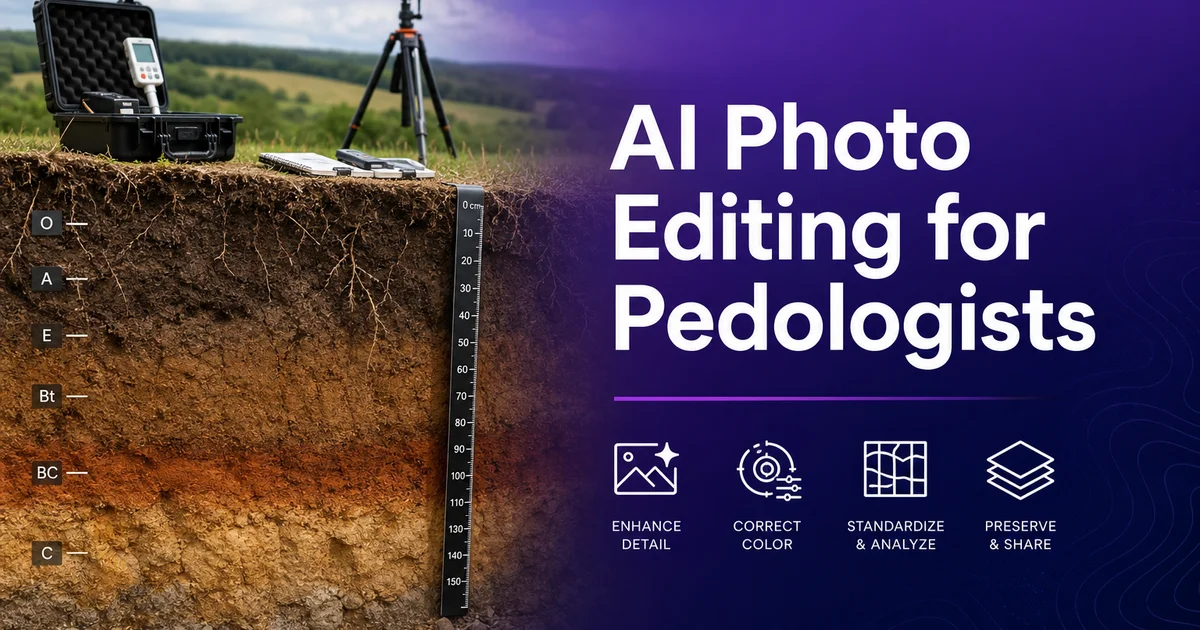
La pédologie -- l'étude des sols dans leur milieu naturel, englobant leur formation, leur classification, leur distribution. La fonction écologique -- repose sur des enregistrements visuels à chaque étape du travail de terrain et de la recherche. Les photographies de profils de sol constituent l'enregistrement visuel principal de l'histoire pédogénétique d'un site, capturant la séquence verticale des horizons qui raconte comment le climat, les organismes, la topographie, le matériau parental. Le temps ont transformé le substrat géologique en sol vivant. Des horizons de surface sombres et riches en matière organique aux horizons B enrichis en minéraux, jusqu'au matériau parental non altéré en dessous, la couleur, la texture, la structure de chaque couche. Les traits des limites portent des informations diagnostiques que les photographies doivent préserver fidèlement.
Les défis photographiques en pédologie sont considérables et systématiques. Les profils de sol sont photographiés dans des fosses excavées en conditions de terrain où l'éclairage varie selon la météo, l'heure, l'orientation de la fosse et la profondeur. La plage tonale d'un seul profil de sol peut s'étendre des couches de surface organiques quasi noires aux horizons carbonatés ou siliceux pâles en profondeur, dépassant la plage dynamique que la plupart des appareils capturent en une seule exposition. L'humidité du sol au moment de la photographie affecte fortement la couleur apparente -- une face de fosse sèche peut paraître plus claire de deux valeurs Munsell que le même profil photographié après la pluie. Et le cadre de terrain introduit des distractions constantes : étaiement de fosse, équipement, racines coupées, débris tombés. Un éclairage inégal dû à l'angle du soleil par rapport à l'ouverture de la fosse.
L'édition photo par IA répond à ces défis en automatisant la normalisation des couleurs, la correction d'exposition. Le traitement de nettoyage que les pédologues effectuent actuellement manuellement -- s'ils l'effectuent. De nombreuses photographies publiées de profils de sol souffrent de dominantes colorées non corrigées, d'expositions inégales. D'artefacts de terrain indésirables simplement parce que les chercheurs manquent de temps ou d'outils pour un post-traitement systématique. Les outils d'IA rendent pratique la production d'images de sol cohérentes, fidèles en couleur, de qualité de publication à partir de captures de terrain, améliorant la valeur scientifique et la clarté visuelle des enregistrements pédologiques.
- La normalisation des couleurs à l'aide de références d'étalonnage garantit la fidélité de la couleur du sol entre des images prises sous des conditions d'éclairage, de météo et d'humidité différentes.
- L'amélioration par IA affine les traits structuraux -- morphologie des peds, limites d'horizons, canaux racinaires et motifs de marbrures -- essentiels à l'identification et à la classification des horizons.
- Magic Eraser supprime les artefacts de terrain comme l'étaiement de fosse, l'équipement et les racines coupées sans altérer la surface diagnostique du profil de sol.
- La correction d'exposition récupère les détails sur toute la plage dynamique, des horizons organiques sombres aux accumulations pâles de carbonate ou de sel.
- Les exports prêts à la publication à 300 DPI avec cartes de référence colorimétrique répondent aux exigences des revues et des bases de données de prospection pédologique.
Précision des couleurs du sol et rôle critique de la photographie calibrée
La couleur est sans doute la propriété visuelle la plus importante en science du sol. Le système de couleurs Munsell -- teinte, valeur. Chroma -- est la norme universelle pour décrire la couleur du sol, et la notation Munsell figure dans pratiquement toute description de sol, rapport de prospection et classification taxonomique. La couleur d'un sol indique directement sa composition et son histoire pédogénétique : les couleurs sombres signalent l'accumulation de matière organique, les rouges et les jaunes indiquent les formes d'oxyde de fer et les conditions de drainage, les gris révèlent des conditions réductrices et un mauvais drainage, les blancs marquent l'accumulation de carbonate ou de sel. Les motifs de marbrures à couleurs multiples documentent les fluctuations de la nappe phréatique. Mal représenter la couleur du sol sur une photographie ne produit pas seulement une image médiocre -- cela produit une désinformation sur les propriétés et la genèse du sol.
Le défi est que la couleur du sol telle que capturée par un appareil est affectée par chaque variable de la chaîne d'imagerie : température de couleur de la lumière ambiante (gris-bleu d'un ciel couvert contre chaleur d'un après-midi en plein soleil), intensité et angle de la lumière, réglage de balance des blancs, traits du capteur, traitements de l'objectif et compression de l'image. Deux photographies du même profil de sol prises à cinq minutes d'intervalle -- l'une au soleil direct, l'autre après le passage d'un nuage -- peuvent montrer des couleurs apparentes très différentes. Un sol humide peut paraître plus sombre de deux valeurs Munsell ou plus que le même sol sec. Sans correction colorimétrique systématique, une collection de photographies de profils de sol issue d'une campagne de terrain de plusieurs jours montrera des incohérences qui sont des artefacts photographiques, et non une variation pédogénétique.
La correction colorimétrique par IA ancrée sur une référence d'étalonnage dans le cadre résout cela de façon systématique. Lorsqu'une charte de couleurs Munsell ou une carte colorimétrique étalonnée est visible sur la photographie, l'IA utilise les valeurs colorimétriques connues des plages de référence pour calculer la matrice de correction nécessaire afin de transformer les couleurs capturées en leurs valeurs réelles sous un éclairage standard. Cette correction est appliquée uniformément sur l'image, normalisant les couleurs du sol à leurs valeurs Munsell réelles indépendamment de l'éclairage ambiant au moment de la capture. Le résultat est un ensemble de photographies de profil où les différences de couleur entre images reflètent de réelles différences de sol plutôt que des conditions photographiques, permettant des comparaisons pertinentes entre sites, saisons et études.
- La notation Munsell de la couleur du sol est la norme universelle -- la couleur indique directement la teneur en matière organique, les formes d'oxyde de fer, les conditions de drainage et l'accumulation de sel.
- La couleur capturée par l'appareil varie selon la température de la lumière, l'intensité, l'angle, la balance des blancs, l'humidité et les caractéristiques du capteur, indépendamment de la couleur réelle du sol.
- La correction par IA à l'aide de références d'étalonnage présentes dans le cadre calcule une matrice de transformation qui normalise les couleurs capturées vers les valeurs réelles sous un éclairage standard.
- Une couleur normalisée sur toute une campagne de terrain garantit que les différences de couleur entre images reflètent une variation pédogénétique plutôt que des artefacts photographiques.
Améliorer la structure du sol et la visibilité des limites d'horizons
La structure du sol -- l'arrangement des particules primaires en agrégats appelés peds -- est une propriété diagnostique clé pour l'identification et la classification des horizons. Elle est notoirement difficile à capturer clairement en photographie. La structure granulaire d'un horizon A bien développé est constituée de petits agrégats à peu près sphériques qui diffusent la lumière selon des motifs complexes. Les peds en blocs angulaires d'un horizon Bt ont des faces planes et des arêtes vives qui créent un motif d'ombre et de lumière différent. Les structures prismatiques et columnaires des horizons de subsurface produisent des motifs verticaux de lumière et d'ombre. La structure lamellaire des couches compactées ou gelées crée des bandes horizontales. Ces motifs structuraux sont tridimensionnels et subtils. La plage dynamique limitée et la perspective plate d'une photographie échouent souvent à transmettre ce que l'observateur de terrain voit clairement sur la face de la fosse.
L'amélioration par IA accroît la visibilité des traits structuraux grâce à un ajustement de contraste local qui souligne la qualité tridimensionnelle des surfaces de peds. Plutôt que d'appliquer un affûtage uniforme qui amplifie le bruit avec le signal, l'IA identifie les motifs répétés propres à la structure du sol -- l'espacement régulier des peds granulaires, les faces planes des agrégats en blocs, l'alignement vertical des colonnes prismatiques -- et augmente le contraste entre les surfaces des peds et les espaces interpédiques. Cela rend le motif structural lisible sur la photographie à un niveau approchant ce que l'observateur de terrain perçoit directement. Cette amélioration est particulièrement précieuse pour les supports pédagogiques et les rapports de prospection où le lecteur doit identifier la structure à partir de la seule photographie, sans l'avantage d'examiner le profil en personne.
Les limites d'horizons portent des informations pédogénétiques clés et sont classées selon leur netteté et leur topographie. Une limite nette et lisse entre un horizon E et un horizon Bt raconte une histoire pédogénétique différente d'une limite graduelle et ondulée entre un Bw et un C. Sur les photographies, les limites graduelles et diffuses sont souvent invisibles parce que l'appareil comprime les transitions subtiles de couleur et de texture que l'œil perçoit sur le terrain. L'amélioration par IA peut augmenter le contraste local spécifiquement le long des zones de limite, rendant les transitions graduelles visibles et conservant la topographie irrégulière des limites ondulées, fragmentées ou en langues qui portent une signification diagnostique pour la classification des sols selon les systèmes Soil Taxonomy et World Reference Base.
- L'amélioration du contraste local par IA rend lisible la qualité tridimensionnelle des surfaces de peds -- les structures granulaire, en blocs, prismatique et lamellaire deviennent chacune visuellement distinctes.
- Les motifs structuraux sont rehaussés en augmentant le contraste entre les faces des peds et les espaces interpédiques plutôt qu'en appliquant un affûtage uniforme qui amplifie le bruit.
- Les limites d'horizons graduelles et diffuses, invisibles sur les photographies brutes, deviennent visibles grâce à un ajustement ciblé du contraste local le long des zones de limite.
- La topographie des limites -- lisse, ondulée, fragmentée ou en langues -- est préservée avec sa signification diagnostique pour la classification selon les systèmes Soil Taxonomy et WRB.
Suppression des artefacts de terrain et standardisation des images de profil
L'excavation d'une fosse pédologique est un processus physiquement exigeant qui introduit avec le temps dans le cadre des éléments visuels ne faisant pas partie du profil de sol. L'étaiement de fosse pour prévenir l'effondrement des parois, les pelles et tarières appuyées contre le bord, les sacs de collecte d'échantillons posés en surface, les carnets de terrain et les crayons servant aux notes de description. Les bottes ou les genoux du descripteur debout au fond de la fosse apparaissent tous dans les photographies de terrain avec une régularité déprimante. Bien que ces éléments fassent partie de l'expérience de terrain, ils sont indésirables dans les images de profil publiées et peuvent masquer des portions du profil porteuses d'informations diagnostiques. La suppression d'artefacts par IA élimine ces distractions tout en conservant la surface du sol dans son état non perturbé.
L'élimination des racines présente un défi spécifique en photographie de profils de sol. Les racines vivantes traversant la face du profil font partie de l'écosystème du sol et peuvent porter des informations diagnostiques -- densité racinaire, profondeur de pénétration, concentration dans des horizons spécifiques. La direction de croissance fournit toutes des informations sur les propriétés physiques et chimiques du sol. Cependant, les racines coupées qui pendent devant la face du profil, les fragments de racines dispersés par l'excavation. Les racines épaisses qui projettent des ombres sur les limites d'horizons gênent l'évaluation visuelle du profil lui-même. Les outils d'IA permettent l'élimination sélective de ces artefacts racinaires problématiques tout en conservant les racines in situ qui restent ancrées dans la face du profil comme partie de l'enregistrement du sol.
Standardiser l'affichage des images sur une étude multi-sites ou un projet de prospection exige plus que la seule correction colorimétrique. Le cadrage, l'orientation, l'échelle et le placement des étiquettes doivent être cohérents afin que les profils soient directement comparables dans les publications, rapports et bases de données. Le traitement par IA peut aider en recadrant et en alignant les images de profil sur un cadre cohérent, garantissant que le ruban d'échelle soit toujours positionné. En normalisant la luminosité et le contraste d'ensemble pour que la série d'images se lise comme un jeu de données visuel cohérent plutôt qu'une collection de photographies de terrain capturées une à une avec une qualité d'affichage variable.
- L'étaiement de fosse, les outils d'excavation, les sacs d'échantillons et autres équipements de terrain sont supprimés sans perturber la surface diagnostique du sol.
- La suppression sélective des artefacts racinaires élimine les racines coupées et déplacées tout en préservant les racines in situ qui portent des informations diagnostiques sur les propriétés du sol.
- La standardisation des images multi-sites garantit un cadrage, une orientation, un placement d'échelle et une luminosité cohérents pour une comparaison directe des profils entre les études.
- Une présentation cohérente transforme des photographies de terrain capturées individuellement en un jeu de données visuel cohérent adapté aux publications et aux bases de données de prospection.
Publication de recherche et applications éducatives
Les photographies de profils de sol sont centrales dans les publications pédologiques -- elles figurent dans les rapports de prospection pédologique, les articles de revues, les manuels, les guides de terrain. Les bases de données numériques utilisées par les chercheurs, gestionnaires de terres et décideurs du monde entier. La qualité de ces images affecte directement leur utilité scientifique. Une photographie de profil bien traitée où les horizons sont clairement différenciés, les traits structuraux visibles, les couleurs fidèles. Une image exempte d'artefacts indésirables transmet plus d'informations pédogénétiques par consultation qu'une capture de terrain brute. Pour les publications dans des revues, cela signifie que relecteurs et lecteurs peuvent évaluer la description et la classification du sol sans avoir à se fier à la seule description verbale de l'auteur -- la photographie fournit une preuve visuelle indépendante.
Les applications pédagogiques en science du sol bénéficient surtout d'une imagerie de profil améliorée. Les étudiants apprenant à identifier les horizons, à décrire la structure. La classification des sols nécessite des références visuelles claires correspondant à ce qu'ils rencontreront sur le terrain. Les photographies de terrain brutes avec dominantes colorées, exposition inégale. Les artefacts indésirables sont de mauvais outils pédagogiques car les étudiants ne peuvent distinguer les propriétés du sol des limites photographiques. Les images traitées par IA aux couleurs fidèles, à la structure visible. Un affichage propre permet aux étudiants de se concentrer sur l'apprentissage de l'interprétation pédologique plutôt que de se débattre avec des problèmes de qualité d'image sans rapport avec la science du sol.
Les bases de données numériques de sols et les outils de prospection pédologique sur le web sont de plus en plus importants pour la planification de l'usage des terres, l'évaluation environnementale et la gestion agricole. Ces bases de données servent des utilisateurs qui ne visiteront peut-être jamais les sites en personne et qui dépendent entièrement du contenu de la base -- y compris les photographies de profil -- pour leur évaluation. Des images de profil de haute qualité, fidèles en couleur et standardisées dans ces bases fournissent une information bien plus utile que les captures de terrain de qualité variable qui les peuplent souvent. À mesure que les bases de données de sols s'étendent pour servir des publics plus larges incluant agriculteurs, ingénieurs, consultants en environnement. Les décideurs, la qualité visuelle de leurs photographies de profil devient de plus en plus importante pour une communication efficace de l'information pédologique.
- Des photographies de profil de qualité de publication fournissent une preuve visuelle indépendante appuyant les descriptions et classifications de sols pour les relecteurs et lecteurs de revues.
- Les étudiants apprenant l'identification des horizons et la classification des sols bénéficient d'une imagerie améliorée aux couleurs fidèles et à la structure visible, exempte d'artefacts photographiques.
- Les bases de données numériques de sols servant planificateurs fonciers, agriculteurs et consultants en environnement requièrent des images standardisées de haute qualité pour un accès à distance efficace à l'information pédologique.
- Le traitement par IA élève toute la qualité visuelle de la documentation pédologique, des limites de la capture de terrain à une présentation cohérente aux standards de publication.
How to do it
- 1
Photograph soil profiles with standardized framing and color reference
Excavate a clean vertical face on the soil pit and photograph the full profile from surface O horizon to the deepest visible horizon or parent material. Include a metric tape measure along the vertical edge and a Munsell color chart or calibrated color card in the frame for post-processing color reference. Use diffused natural light or a consistent artificial light source positioned to illuminate the profile face evenly without creating harsh shadows in horizon boundary recesses or root channels. Photograph the full profile first, then individual horizons at closer range for texture and structure detail.
- 2
Remove field clutter and isolate the soil profile
Use Magic Eraser to remove unwanted elements from soil profile photographs -- pit wall supports, excavation equipment handles visible at the frame edge, roots that have been severed and hang in front of the profile face, sample bags. Field notebooks accidentally captured in the background. Use Background Eraser to isolate individual soil aggregates, root cross-sections, or hand samples from the field background for detailed analysis or figure preparation. Keep the profile face completely intact while removing only elements that are not part of the soil itself.
- 3
Normalize soil color for accurate horizon identification
Apply AI Enhance color correction using the Munsell chart or color reference card in the frame to normalize white balance and exposure across all profile images from a field campaign. Consistent, accurate soil color representation is key because color is a primary diagnostic criterion for horizon spotting -- the dark brown to black of an A horizon's organic matter, the reddish-yellow of iron oxide accumulation in a Bt horizon, the gray mottling of gleyed conditions. The white of carbonate or salt efflorescence all carry pedogenic meaning. Images captured on cloudy versus sunny days, in morning versus afternoon light, or with wet versus dry pit faces must be normalized for meaningful comparison.
- 4
Enhance structural features and horizon boundary detail
Use AI Enhance to sharpen the textural and structural features that define soil horizons -- the granular structure of a well-developed A horizon, the angular blocky peds of a Bt horizon, platy structure in compacted layers. The massive or single-grain structure of C horizon parent material. Increase local contrast along horizon boundaries to make gradual or diffuse transitions visible in the photograph, mainly where a photograph's dynamic range compresses the subtle color and texture changes that are apparent to the eye in the field but lost in the camera capture.
- 5
Export soil profile images for publication and database submission
Save all profile images in PNG format to preserve color accuracy and textural detail without compression artifacts. For journal publications, export at 300 DPI minimum with the color reference card visible in calibration frames. For soil survey databases and digital archives, follow the metadata and resolution specifications of the target repository. Include standardized file naming with site identifier, profile number, horizon designation. Capture date for efficient database retrieval and cross-referencing across multi-site studies.
Sources
- Guidelines for Soil Description and Classification — Food and Agriculture Organization of the United Nations
- Soil Survey Manual: Photographing Soil Profiles — USDA Natural Resources Conservation Service
- Munsell Soil Color Charts and Digital Color Measurement — Munsell Color / X-Rite