
Photo aérienne de drone
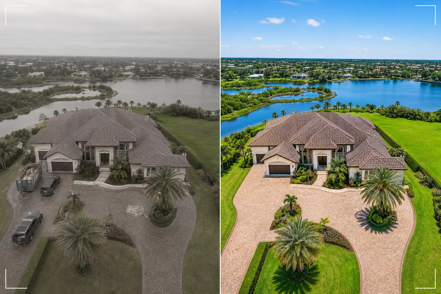
Transformez les images fixes de vos drones en superbes vues aériennes. Ce modèle remplace les ciels couverts, renforce l'éclat des couleurs du paysage, supprime les véhicules et équipements de chantier indésirables, accentue les détails du bien visibles d'en haut et corrige le profil colorimétrique plat fréquent dans les images de caméra de drone.
Essayer ce modèle gratuitementReal Estate template preview
Ce que fait ce modèle
Traite les photos aériennes de drone pour les annonces immobilières, le marketing de biens, les relevés fonciers et la documentation architecturale. Les caméras de drone filment généralement avec un profil colorimétrique plat conçu pour l'étalonnage vidéo, ce qui rend les photos fixes désaturées et brumeuses par rapport aux clichés de caméras dédiées. Ce modèle applique une correction colorimétrique ciblée qui restitue des verts de paysage éclatants, des tuiles de toit saturées et des cours d'eau d'un bleu limpide à partir de la sortie plate du drone. Magic Eraser supprime les véhicules, les équipements de chantier, les bennes et autres objets temporaires visibles d'en haut qui rendent un bien moins attrayant. AI Enhance accentue les contours des bâtiments, les détails d'aménagement paysager et les caractéristiques du bien que l'altitude du drone et la brume atmosphérique ont tendance à adoucir.
Paramètres du modèle
| Remplacement du ciel | Ciel bleu clair ou heure dorée (correspondant à la direction de la lumière au sol) |
| Couleur du paysage | Herbe verte éclatante, feuillage saturé, tons d'eau limpides |
| Suppression de la brume | Correction de la brume atmosphérique et du flou lié à l'altitude du drone |
| Suppression d'objets | Supprimer les véhicules, les bennes et les équipements de chantier |
| Résolution de sortie | 5000px sur le bord long (prêt pour l'impression et l'affichage grand format) |
Comment utiliser ce modèle
Importez votre photo de drone
Importez une image fixe de votre drone — DJI, Autel, Skydio ou toute autre plateforme. Le modèle prend en charge à la fois les fichiers DNG bruts et la sortie JPEG compressée. Pour de meilleurs résultats, photographiez à l'altitude la plus basse possible permettant de capturer l'ensemble du bien et de ses environs, car les prises de vue plus rapprochées offrent plus de détails à améliorer pour l'IA.
Correction du ciel et des couleurs
Les ciels couverts ou brumeux sont remplacés par des alternatives de ciel bleu clair ou d'heure dorée qui correspondent à la direction de la lumière au sol. Le profil colorimétrique plat du drone est corrigé pour produire des verts de paysage riches, des tons de bâtiment chaleureux et une eau d'un bleu limpide le cas échéant. La brume atmosphérique est supprimée pour restaurer la netteté.
Supprimez les objets indésirables
Magic Eraser supprime les véhicules dans les allées et les rues, les bennes de chantier, les toilettes portables, les équipements et tout objet temporaire visible d'en haut. L'IA reconstruit l'allée, la pelouse, la surface de la route ou la toiture derrière les objets supprimés en utilisant le contexte environnant.
Exportez pour annonce ou présentation
Téléchargez à 5000px sur le bord long pour les tirages grand format et les panneaux de présentation, ou à des dimensions optimisées pour le web pour les annonces MLS et les sites immobiliers. La perspective aérienne améliorée offre une vue d'ensemble complète du bien que les photos au niveau du sol ne peuvent pas atteindre.
Conseils de pro pour de meilleurs résultats
- ✓Volez pendant l'heure dorée (l'heure qui suit le lever ou précède le coucher du soleil) pour l'éclairage le plus spectaculaire. La lumière du soleil à faible angle crée de longues ombres qui révèlent le relief du terrain et ajoutent du volume aux bâtiments. Le modèle peut améliorer n'importe quel moment de la journée, mais les vues aériennes à l'heure dorée constituent le point de départ le plus saisissant visuellement.
- ✓Capturez à la fois une vue d'ensemble à haute altitude (montrant l'ensemble du bien et le contexte du quartier) et une prise de vue de détail à basse altitude (montrant le bâtiment, l'aménagement paysager et les espaces de vie extérieurs). Traitez les deux avec le modèle pour une perspective aérienne complète.
- ✓Pour les biens en bord d'eau, planifiez votre vol par temps d'eau calme. Une eau lisse comme un miroir produit des reflets plus nets et des tons bleus plus attrayants que le modèle met en valeur. Une eau agitée peut sembler encombrée vue d'en haut et est plus difficile à améliorer pour atteindre une finition digne d'un magazine.
Outils
Questions fréquentes
Cela peut-il corriger les photos de drone prises par temps couvert ?
+
Oui. Le remplacement d'un ciel couvert est l'une des améliorations les plus impactantes. Le modèle remplace le ciel blanc et plat par un ciel bleu naturel dont la direction de l'éclairage correspond à la lumière douce et uniforme déjà présente au sol — ce qui est en fait avantageux, car la lumière couverte crée un minimum d'ombres dures sur les bâtiments.
Et les prises de vue à haute altitude avec brume atmosphérique ?
+
Le modèle comprend une étape dédiée de suppression de la brume qui restaure le contraste et la saturation des couleurs perdus à cause de la brume atmosphérique en altitude. C'est le plus efficace pour les prises de vue réalisées entre 100 et 400 pieds, où la brume est présente mais le sujet reste suffisamment proche pour conserver les détails.
Puis-je traiter des images de séquences vidéo de drone ?
+
Oui. Extrayez les meilleures images fixes de votre vidéo de drone 4K et traitez-les avec le modèle. Les images vidéo ont une résolution inférieure aux photos fixes dédiées (8 à 12 MP contre 20 à 48 MP), donc le résultat sera légèrement moins détaillé, mais la correction des couleurs et le remplacement du ciel restent pleinement efficaces.
Des vues aériennes qui vendent les biens vus d'en haut
Importez vos photos de drone et obtenez des images aériennes au ciel sublimé et aux couleurs corrigées qui mettent les biens en valeur sous leur jour le plus impressionnant.
Essayer gratuitementRelated templates
More real estate templates for your workflow.
Modèle de photo immobilière professionnelle pour les annonces MLS. Amélioration de type HDR, remplacement du ciel, suppression de l'encombrement et correction des couleurs pour des photos de propriété qui se vendent plus rapidement.
Sublimez vos photos d'extérieur architectural avec correction des lignes verticales, remplacement du ciel, suppression des voitures et piétons, et étalonnage heure dorée pour annonces et portfolios.
Transformez les photos Airbnb et de location de vacances avec l'éclaircissement de la pièce, la suppression de l'encombrement, Color correction et la correction de la distorsion de l'objectif grand angle pour des tarifs de réservation plus élevés.
Améliorez les photos de votre portefeuille de décoration d'intérieur en éclaircissant la pièce, en supprimant l'encombrement, en accentuant la texture des matériaux et en rendant les couleurs précises des finitions et des tissus.
Mettez en scène virtuellement des pièces vides avec des meubles, une décoration et un éclairage réalistes. Aidez les acheteurs à visualiser les espaces de vie sans frais de mise en scène physique.
Nettoyez, améliorez et standardisez les images de plans d'étage pour les annonces immobilières avec l'élimination des taches, la netteté des lignes et un style cohérent.