
صورة جوية بطائرة بدون طيار
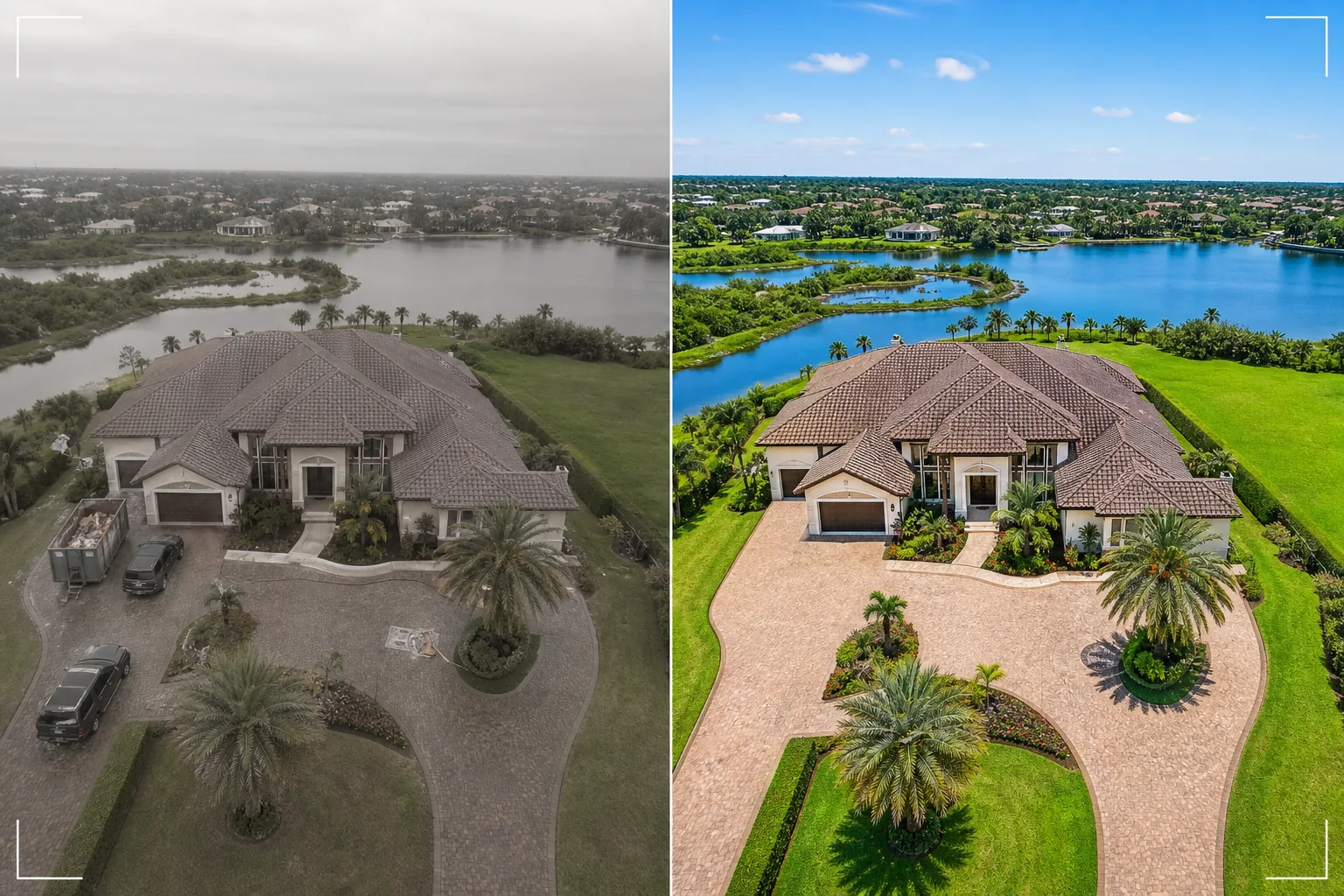
حوّل اللقطات الثابتة من تصوير الطائرات بدون طيار إلى صور جوية مذهلة. يستبدل هذا القالب السماء الملبدة بالغيوم، ويعزز حيوية ألوان المناظر الطبيعية، ويزيل المركبات ومعدات البناء غير المرغوب فيها، ويزيد من حدة تفاصيل العقار المرئية من الأعلى، ويصحح ملف الألوان المسطح الشائع في لقطات كاميرات الطائرات بدون طيار.
جرّب هذا القالب مجانًاReal Estate template preview
ماذا يفعل هذا القالب
يعالج الصور الجوية الملتقطة بالطائرات بدون طيار لإعلانات العقارات وتسويق العقارات ومسوحات الأراضي والتوثيق المعماري. عادةً ما تصوّر كاميرات الطائرات بدون طيار بملف ألوان مسطح مصمم لتدرج ألوان الفيديو، مما يجعل الصور الثابتة تبدو باهتة وضبابية مقارنةً بلقطات الكاميرات المخصصة. يطبّق هذا القالب تصحيحًا لونيًا مستهدفًا يستعيد الخُضرة النابضة بالحياة للمناظر الطبيعية، وقرميد الأسطح المشبع بالألوان، والممرات المائية الزرقاء الصافية من مخرجات الطائرة بدون طيار المسطحة. يزيل Magic Eraser المركبات ومعدات البناء وحاويات النفايات وغيرها من الأجسام المؤقتة المرئية من الأعلى التي تجعل العقار يبدو أقل جاذبية. ويزيد AI Enhance من حدة حواف المباني وتفاصيل تنسيق الحدائق وميزات العقار التي يميل ارتفاع الطائرة بدون طيار والضباب الجوي إلى تنعيمها.
إعدادات القالب
| استبدال السماء | سماء زرقاء صافية أو الساعة الذهبية (بما يتوافق مع اتجاه الضوء على الأرض) |
| لون المناظر الطبيعية | عشب أخضر نابض بالحياة، أوراق شجر مشبعة بالألوان، درجات مائية صافية |
| إزالة الضباب | تصحيح الضباب الجوي والنعومة الناتجة عن ارتفاع الطائرة بدون طيار |
| إزالة الأجسام | إزالة المركبات وحاويات النفايات ومعدات البناء |
| دقة الإخراج | 5000px للحافة الطويلة (جاهز للطباعة والعرض كبير الحجم) |
كيفية استخدام هذا القالب
حمّل صورة الطائرة بدون طيار الخاصة بك
حمّل لقطة ثابتة من طائرتك بدون طيار — DJI أو Autel أو Skydio أو أي منصة أخرى. يتعامل القالب مع كل من ملفات DNG الخام ومخرجات JPEG المضغوطة. للحصول على أفضل النتائج، صوّر على أقل ارتفاع متاح يلتقط العقار بالكامل ومحيطه، لأن اللقطات الأقرب تحتوي على تفاصيل أكثر ليحسّنها الذكاء الاصطناعي.
تصحيح السماء والألوان
يتم استبدال السماء الملبدة بالغيوم أو الضبابية ببدائل من السماء الزرقاء الصافية أو الساعة الذهبية التي تتوافق مع اتجاه الضوء على الأرض في الأسفل. يتم تصحيح ملف الألوان المسطح للطائرة بدون طيار لإنتاج خُضرة غنية للمناظر الطبيعية ودرجات دافئة للمباني ومياه زرقاء صافية إن وُجدت. تتم إزالة الضباب الجوي لاستعادة الوضوح.
إزالة الأجسام غير المرغوب فيها
يزيل Magic Eraser المركبات في الممرات والشوارع، وحاويات نفايات البناء، والمراحيض المتنقلة، والمعدات، وأي أجسام مؤقتة مرئية من الأعلى. يعيد الذكاء الاصطناعي بناء الممر أو المرج أو سطح الطريق أو السطح خلف الأجسام المُزالة باستخدام السياق المحيط.
التصدير للإعلان أو العرض التقديمي
نزّل بحافة طويلة 5000px للمطبوعات كبيرة الحجم ولوحات العرض، أو بأبعاد محسّنة للويب لإعلانات MLS ومواقع العقارات. يوفر المنظور الجوي المحسّن نظرة عامة شاملة على العقار لا يمكن أن تحققها الصور على مستوى الأرض.
نصائح احترافية لأفضل النتائج
- ✓حلّق خلال الساعة الذهبية (الساعة التي تلي شروق الشمس أو تسبق غروبها) للحصول على أكثر إضاءة درامية. يخلق ضوء الشمس منخفض الزاوية ظلالًا طويلة تكشف عن تضاريس الأرض وتضيف بُعدًا للمباني. يمكن للقالب تحسين أي وقت من اليوم، لكن الصور الجوية في الساعة الذهبية هي نقطة الانطلاق الأكثر تأثيرًا بصريًا.
- ✓التقط نظرة عامة من ارتفاع عالٍ (تُظهر العقار بالكامل وسياق الحي) ولقطة تفصيلية من ارتفاع منخفض (تُظهر المبنى وتنسيق الحدائق ومساحات المعيشة الخارجية). عالِج كليهما عبر القالب للحصول على منظور جوي كامل.
- ✓بالنسبة للعقارات المطلة على الماء، حدد موعد تحليقك في ظروف المياه الهادئة. تنتج المياه الزجاجية الناعمة انعكاسات أنظف ودرجات زرقاء أكثر جاذبية يعززها القالب. قد تبدو المياه المتموجة فوضوية من الأعلى ويصعب تحسينها لتصل إلى جودة المجلات.
เครื่องมือ
أسئلة شائعة
هل يمكن لهذا إصلاح صور الطائرة بدون طيار الملتقطة في الأيام الملبدة بالغيوم؟
+
نعم. يُعد استبدال السماء الملبدة بالغيوم أحد أكثر التحسينات تأثيرًا. يستبدل القالب السماء البيضاء المسطحة بسماء زرقاء طبيعية يتوافق اتجاه إضاءتها مع الإضاءة الناعمة المتساوية الموجودة بالفعل على الأرض — وهو أمر مفيد في الواقع لأن ضوء الأيام الملبدة بالغيوم يخلق أقل قدر من الظلال القاسية على المباني.
ماذا عن اللقطات من ارتفاع عالٍ مع الضباب الجوي؟
+
يتضمن القالب خطوة مخصصة لإزالة الضباب تستعيد التباين وتشبع الألوان المفقودين بسبب الضباب الجوي على الارتفاعات. وهذا أكثر فعالية للقطات الملتقطة بين 100 و400 قدم حيث يكون الضباب موجودًا لكن الهدف لا يزال قريبًا بما يكفي للاحتفاظ بالتفاصيل.
هل يمكنني معالجة إطارات الفيديو من لقطات الطائرة بدون طيار؟
+
نعم. استخرج أفضل الإطارات الثابتة من فيديو الطائرة بدون طيار بدقة 4K وعالِجها عبر القالب. تكون إطارات الفيديو بدقة أقل من الصور الثابتة المخصصة (8–12 ميجابكسل مقابل 20–48 ميجابكسل)، لذا ستكون المخرجات أقل تفصيلاً قليلاً، لكن تصحيح الألوان واستبدال السماء فعّالان تمامًا.
مناظر جوية تبيع العقارات من الأعلى
حمّل صور الطائرة بدون طيار واحصل على صور جوية محسّنة السماء ومصححة الألوان تعرض العقارات في أكثر صورها إثارة للإعجاب.
جرّبه مجانًاRelated templates
More real estate templates for your workflow.
เทมเพลตภาพถ่ายอสังหาริมทรัพย์ระดับมืออาชีพสำหรับประกาศ MLS การปรับแต่งแบบ HDR, การแทนที่ท้องฟ้า, การกำจัดสิ่งรกรุงรัง และการแก้สีสำหรับภาพถ่ายอสังหาริมทรัพย์ที่ขายได้เร็วขึ้น
ยกระดับภาพภายนอกสถาปัตยกรรมด้วยการแก้ไขเส้นแนวตั้ง แทนที่ท้องฟ้า ลบรถและคนเดินเท้า และปรับสีโทนชั่วโมงทองสำหรับประกาศขายและพอร์ตโฟลิโอ
แปลงโฉมรูปภาพ Airbnb และห้องเช่าวันหยุดด้วยการเพิ่มความสว่างของห้อง การกำจัดสิ่งยุ่งเหยิง Color correction และการแก้ไขความผิดเพี้ยนของเลนส์มุมกว้างเพื่อให้ได้อัตราการจองที่สูงขึ้น
ปรับปรุงภาพถ่ายพอร์ตโฟลิโอการออกแบบตกแต่งภายในด้วยการปรับความสว่างของห้อง การกำจัดสิ่งยุ่งเหยิง การทำให้พื้นผิวของวัสดุคมชัดขึ้น และการแสดงสีที่แม่นยำของพื้นผิวและผ้า
จัดแสดงห้องว่างแบบเสมือนจริงด้วยเฟอร์นิเจอร์ การตกแต่ง และแสงไฟที่สมจริง ช่วยให้ผู้ซื้อเห็นภาพพื้นที่อยู่อาศัยได้โดยไม่ต้องเสียค่าใช้จ่ายในการจัดวางจริง
ทำความสะอาด ปรับปรุง และสร้างมาตรฐานให้กับภาพแผนผังชั้นสำหรับรายการอสังหาริมทรัพย์ด้วยการขจัดคราบ การทำให้เส้นคมชัด และการจัดสไตล์ที่สม่ำเสมอ