
Аэрофотоснимок с дрона
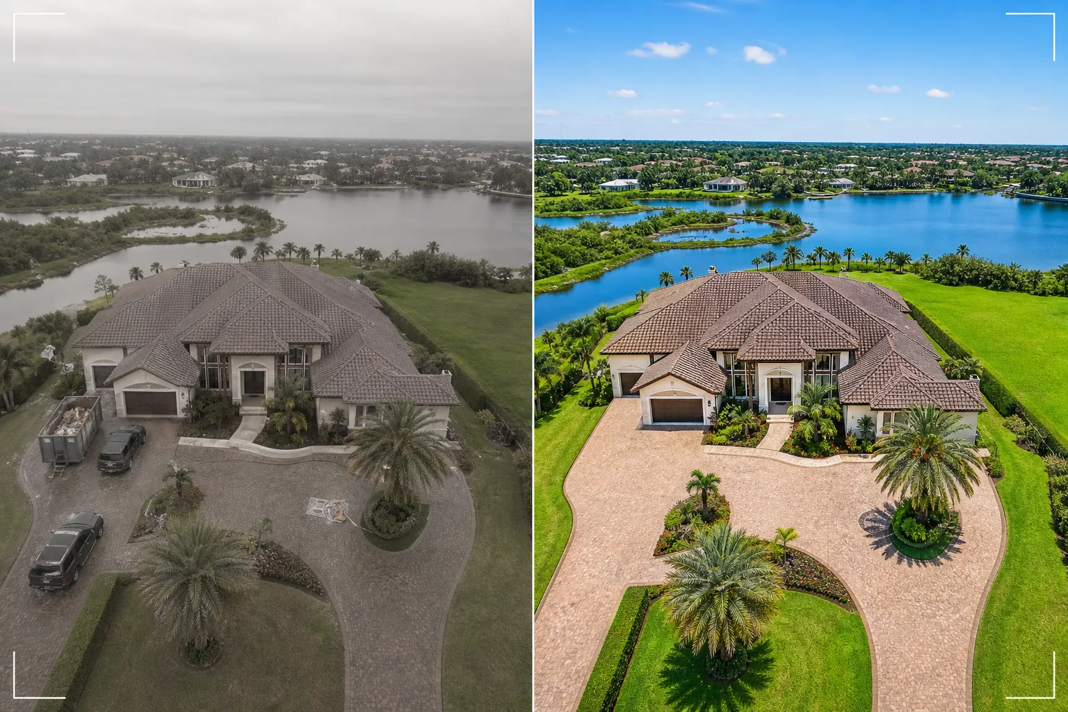
Превращайте стоп-кадры с дрона в потрясающие аэрофотоснимки. Этот шаблон заменяет пасмурное небо, усиливает яркость цветов ландшафта, удаляет нежелательные транспортные средства и строительную технику, повышает резкость деталей объекта, видимых сверху, и корректирует плоский цветовой профиль, характерный для съёмки камерами дронов.
Попробовать этот шаблон бесплатноReal Estate template preview
Что делает этот шаблон
Обрабатывает аэрофотоснимки с дрона для объявлений о недвижимости, маркетинга объектов, землемерных работ и архитектурной документации. Камеры дронов обычно снимают с плоским цветовым профилем, разработанным для цветокоррекции видео, из-за чего стоп-кадры выглядят обесцвеченными и мутными по сравнению со снимками специализированных камер. Этот шаблон применяет целенаправленную цветокоррекцию, которая восстанавливает яркую зелень ландшафта, насыщенную черепицу крыш и чистые голубые водные пути из плоского вывода дрона. Magic Eraser удаляет транспортные средства, строительную технику, мусорные контейнеры и другие временные объекты, видимые сверху, из-за которых объект выглядит менее привлекательным. AI Enhance повышает резкость краёв зданий, деталей ландшафтного дизайна и характеристик объекта, которые высота полёта дрона и атмосферная дымка склонны смягчать.
Настройки шаблона
| Замена неба | Чистое голубое небо или золотой час (в соответствии с направлением света на земле) |
| Цвет ландшафта | Яркая зелёная трава, насыщенная листва, чистые тона воды |
| Удаление дымки | Коррекция атмосферной дымки и смягчения из-за высоты полёта дрона |
| Удаление объектов | Удаление транспортных средств, мусорных контейнеров и строительной техники |
| Разрешение вывода | 5000px по длинной стороне (готово к печати и отображению в большом формате) |
Как использовать этот шаблон
Загрузите фото с дрона
Загрузите стоп-кадр с вашего дрона — DJI, Autel, Skydio или любой другой платформы. Шаблон работает как с необработанными файлами DNG, так и со сжатым выводом JPEG. Для наилучших результатов снимайте на наименьшей доступной высоте, захватывающей весь объект и его окружение, поскольку более близкие снимки содержат больше деталей для усиления ИИ.
Коррекция неба и цвета
Пасмурное или мутное небо заменяется чистым голубым или вариантами золотого часа, соответствующими направлению света на земле внизу. Плоский цветовой профиль дрона корректируется для получения насыщенной зелени ландшафта, тёплых тонов зданий и чистой голубой воды, если она присутствует. Атмосферная дымка удаляется для восстановления чёткости.
Удалите нежелательные объекты
Magic Eraser удаляет транспортные средства на подъездных дорожках и улицах, строительные мусорные контейнеры, переносные туалеты, технику и любые временные объекты, видимые сверху. ИИ реконструирует подъездную дорожку, газон, поверхность дороги или крышу за удалёнными объектами, используя окружающий контекст.
Экспорт для объявления или презентации
Скачайте с длинной стороной 5000px для крупноформатной печати и презентационных стендов или в оптимизированных для веба размерах для объявлений MLS и сайтов недвижимости. Улучшенная воздушная перспектива обеспечивает всесторонний обзор объекта, недостижимый для снимков с уровня земли.
Профессиональные советы для лучших результатов
- ✓Летайте во время золотого часа (час после восхода или перед закатом) для наиболее эффектного освещения. Низкий угол солнечного света создаёт длинные тени, которые выявляют рельеф местности и придают зданиям объём. Шаблон может улучшить снимок в любое время суток, но аэрофотоснимки золотого часа — наиболее визуально впечатляющая отправная точка.
- ✓Сделайте как обзорный снимок с большой высоты (показывающий весь объект и контекст района), так и детальный снимок с малой высоты (показывающий здание, ландшафтный дизайн и открытые жилые пространства). Обработайте оба через шаблон для полной воздушной перспективы.
- ✓Для объектов на берегу планируйте полёт при спокойной воде. Гладкая, как зеркало, вода даёт более чистые отражения и более привлекательные голубые тона, которые шаблон усиливает. Неспокойная вода может выглядеть сверху загромождённой, и её сложнее довести до качества журнального уровня.
Ferramentas
Частые вопросы
Может ли это исправить фото с дрона, снятые в пасмурные дни?
+
Да. Замена пасмурного неба — одно из наиболее эффективных улучшений. Шаблон заменяет плоское белое небо естественным голубым небом, направление освещения которого соответствует мягкому, равномерному свету, уже имеющемуся на земле, — что фактически является преимуществом, поскольку пасмурный свет создаёт минимум резких теней на зданиях.
А как насчёт снимков с большой высоты с атмосферной дымкой?
+
Шаблон включает специальный этап удаления дымки, который восстанавливает контраст и насыщенность цвета, потерянные из-за атмосферной дымки на высоте. Это наиболее эффективно для снимков, сделанных на высоте от 100 до 400 футов, где дымка присутствует, но объект всё ещё достаточно близок, чтобы сохранить детали.
Могу ли я обрабатывать видеокадры из съёмки дрона?
+
Да. Извлеките лучшие стоп-кадры из вашего видео с дрона 4K и обработайте их через шаблон. Видеокадры имеют более низкое разрешение, чем специализированные фотоснимки (8–12 МП против 20–48 МП), поэтому результат будет немного менее детализированным, но цветокоррекция и замена неба полностью эффективны.
Воздушные виды, которые продают недвижимость сверху
Загрузите фото с дрона и получите аэрофотоснимки с улучшенным небом и скорректированным цветом, которые показывают объекты в самом впечатляющем виде.
Попробовать бесплатноRelated templates
More real estate templates for your workflow.
Modelo profissional de fotos imobiliárias para listagens da MLS. Aprimoramento semelhante ao HDR, substituição do céu, remoção de desordem e correção de cores para fotos de propriedades que vendem mais rapidamente.
Aprimore fotos de exteriores arquitetônicos com correção de linhas verticais, substituição de céu, remoção de carros e pedestres e gradação de cor da hora dourada para anúncios e portfólios.
Transforme fotos do Airbnb e de aluguel por temporada com iluminação de quarto, remoção de desordem, Color correction e correção de distorção de lente grande angular para taxas de reserva mais altas.
Aprimore as fotos do portfólio de design de interiores com iluminação de ambiente, remoção de desordem, nitidez de textura de material e renderização de cores precisas de acabamentos e tecidos.
Crie ambientes vazios virtualmente com móveis, decoração e iluminação realistas. Ajude os compradores a visualizar espaços residenciais sem custos de preparação física.
Limpe, aprimore e padronize imagens de plantas baixas para listagens de imóveis com remoção de manchas, nitidez de linhas e estilo consistente.