
Como Editar Fotos de Drone e Aéreas: Fluxos de Trabalho com IA para Resultados Impressionantes
Aprenda a editar fotos de drone e aéreas usando ferramentas de IA. Corrija neblina, remova objetos indesejados, ajuste exposição. Melhore detalhes para transformar fotos aéreas em imagens de qualidade profissional para imobiliária, paisagens e uso comercial.

Product Marketing
Revisado por Magic Eraser Editorial ·
Índice
- Por que fotos de drone precisam de edição especializada
- Removendo objetos e distrações de fotos aéreas
- Corrigindo neblina, exposição e cor em fotos aéreas
- Nitidez e redução de ruído para sensores de drone
- Fluxos de trabalho de edição para fotografia imobiliária e comercial com drone
- Exportando e entregando imagens aéreas
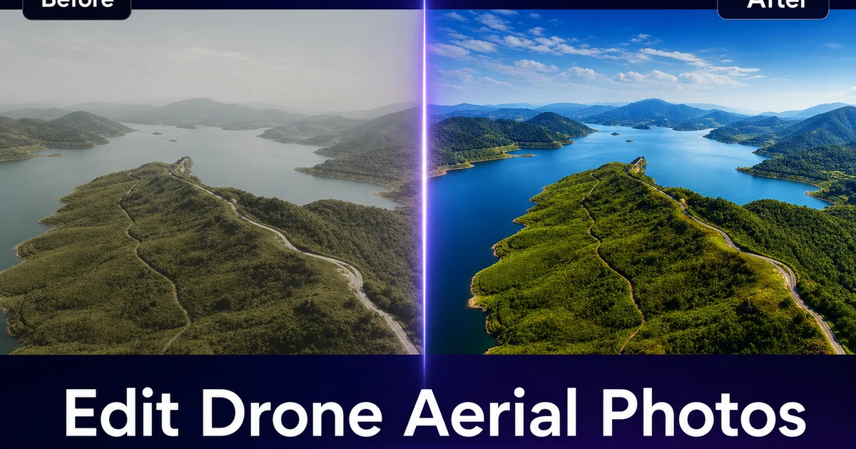
A fotografia com drone captura perspectivas que câmeras terrestres simplesmente não conseguem alcançar. Panoramas abrangentes de paisagens, vistas aéreas de propriedades, registros de progresso em construções e composições cinematográficas de viagens. Mas o ponto de vista único que torna as fotos de drone impressionantes também traz desafios de edição que os fluxos de trabalho fotográficos tradicionais não foram projetados para resolver. A neblina atmosférica degrada detalhes distantes, a distorção grande-angular deforma as bordas, exposições misturadas deixam sombras muito escuras e céus estourados. Sensores pequenos em drones de consumo introduzem ruído em qualquer ISO acima do base.
A maioria dos fotógrafos de drone gasta muito tempo editando cada imagem em aplicativos de desktop como Lightroom ou Photoshop, ajustando dezenas de controles deslizantes manualmente e aplicando máscaras seletivas. Ferramentas de edição com AI podem automatizar as partes mais demoradas desse fluxo de trabalho. Remoção de neblina, balanceamento de exposição, redução de ruído e limpeza de objetos — reduzindo o tempo de edição de minutos para segundos por imagem sem sacrificar a qualidade.
Este guia aborda os desafios específicos de edição que fotógrafos de drone enfrentam e os fluxos de trabalho com IA que os resolvem, seja você fotografando aéreas imobiliárias, paisagens, registros de construção ou conteúdo comercial.
- A remoção de neblina com IA elimina a interferência atmosférica para restaurar clareza e cor em detalhes distantes da paisagem.
- A remoção de objetos apaga carros, pessoas, equipamentos de construção e outras distrações de composições aéreas sem deixar artefatos.
- A correção de exposição com IA equilibra céus claros contra sombras escuras no solo — o desafio de faixa dinâmica mais comum em fotos aéreas.
- A redução de ruído preserva detalhes finos da paisagem enquanto remove o ruído de luminância comum em sensores pequenos de drone.
- Um único passe de AI Enhance corrige temperatura de cor, exposição e clareza simultaneamente para fotos aéreas.
- O processamento em lote permite que fotógrafos de drone editem centenas de imagens de levantamento ou inspeção em uma fração do tempo.
Por que fotos de drone precisam de edição especializada
As câmeras de drone enfrentam restrições ambientais e de hardware que câmeras terrestres em grande parte evitam. A mais significativa é a interferência atmosférica. Mesmo em um dia claro, a coluna de ar entre um drone a 120 metros de altitude e o solo contém umidade, poeira e material particulado suficientes para reduzir o contraste, alterar a cor e suavizar detalhes. Esse efeito é visível em toda foto aérea como uma leve névoa que se intensifica com a distância da câmera. Em dias úmidos ou em áreas urbanas com poluição, a névoa pode transformar edifícios e terrenos distantes em formas cinzas sem características.
A faixa dinâmica é o segundo desafio. Fotos aéreas quase sempre incluem céu claro na parte superior e solo mais escuro na parte inferior. A diferença de exposição entre essas zonas frequentemente excede o que o sensor pequeno de um drone pode capturar em um único quadro. O resultado é um solo devidamente exposto com um céu branco estourado, ou um céu devidamente exposto com sombras escuras e sem detalhes no solo. A DJI e outros fabricantes oferecem modos de exposição com bracketing. Muitos pilotos fotografam em quadro único por rapidez ou porque sua missão não permite pairar.
As lentes de drone são frequentemente grande-angulares, variando de 20mm a 28mm equivalentes. Essas distâncias focais capturam cenas amplas, mas introduzem distorção em barril que curva linhas retas próximas às bordas do quadro. Visível em fachadas de edifícios, bordas de estradas e linhas do horizonte. Sensores pequenos também geram mais ruído do que câmeras full-frame em configurações ISO equivalentes. Pilotos frequentemente aumentam o ISO para manter velocidades de obturação rápidas que evitam desfoque de movimento causado pela vibração do drone.
- A neblina atmosférica reduz o contraste e altera a cor em toda foto aérea, piorando com altitude e umidade.
- A faixa dinâmica entre céu claro e sombras escuras no solo excede a capacidade de quadro único da maioria dos sensores de drone.
- Lentes grande-angulares de drone introduzem distorção em barril visível em linhas retas e bordas do horizonte.
- Sensores pequenos produzem mais ruído, especialmente em valores ISO acima do base.
Removendo objetos e distrações de fotos aéreas
A perspectiva aérea que torna as fotos de drone visualmente impressionantes também captura tudo abaixo. Incluindo elementos que você não deseja na imagem final. Aéreas imobiliárias captam o ferro-velho do vizinho, unidades de HVAC no telhado e caminhões de mudança estacionados. Fotos de paisagens capturam caminhantes, linhas de energia e estradas de acesso. Fotos de progresso de construção incluem banheiros químicos, contêineres de lixo e áreas de preparação que são irrelevantes para o propósito do registro.
O Magic Eraser é especialmente eficaz em imagens aéreas porque a perspectiva superior cria texturas bastante uniformes. Grama, asfalto, telhados, água, dossel florestal — que a IA pode reconstruir de forma convincente após remover um objeto. Pincele sobre uma fileira de carros estacionados em uma aérea imobiliária e a IA preenche a superfície da entrada ou do estacionamento. Remova um guindaste de construção de uma foto do horizonte e a IA reconstrói o gradiente do céu e os edifícios distantes. Apague linhas de energia cruzando uma composição de paisagem e a IA as substitui pelo dossel das árvores e pelo céu que deveriam estar visíveis atrás delas.
Para fotografia de inspeção e levantamento, remova apenas elementos genuinamente indesejados ou irrelevantes. Uma foto de inspeção de telhado deve mostrar todas as condições reais do telhado; uma foto de progresso deve documentar as condições reais do local. A remoção de objetos é uma ferramenta composicional para imagens de marketing e portfólio, não uma ferramenta de alteração de registros para trabalho técnico especializado.
- Perspectivas aéreas capturam texturas de solo uniformes que a IA pode reconstruir de forma convincente após a remoção de objetos.
- Remova carros estacionados, equipamentos de construção, linhas de energia e pessoas para limpar composições.
- Para fotos de levantamento e inspeção, remova apenas distrações composicionais — nunca altere condições documentadas.
Corrigindo neblina, exposição e cor em fotos aéreas
A remoção de neblina é frequentemente a edição mais transformadora para uma foto de drone. O AI Enhance analisa a imagem para detectar interferência atmosférica e restaura contraste, saturação de cor e detalhes finos em porções distantes da cena. Uma foto de paisagem que parecia plana e desbotada ganha profundidade e dimensão. Uma cidade onde edifícios distantes eram quase invisíveis se torna nítida e detalhada em todo o quadro.
A correção de exposição em fotos aéreas requer equilibrar duas zonas distintas: o céu claro acima e o solo mais escuro abaixo. O AI Enhance lida com isso como um ajuste local, elevando detalhes de sombra no solo enquanto preserva a tonalidade do céu e os detalhes das nuvens. Isso equivale a mascaramento de luminosidade manual no Photoshop, mas acontece automaticamente em um único passe. Para exposições com bracketing, o AI Enhance pode otimizar um único quadro que se aproxima da faixa dinâmica de uma mesclagem HDR processada manualmente.
A precisão de cor em fotos aéreas é afetada pela própria atmosfera. A luz quente da manhã dá às aéreas um tom dourado. O sol do meio-dia acima da neblina cria uma mudança azulada fria. A poluição urbana adiciona um tom amarelo-acastanhado. O AI Enhance normaliza o balanço de branco com base no conteúdo da cena, produzindo cores precisas independentemente das condições atmosféricas. Isso é especialmente importante para aéreas imobiliárias, onde a cor do telhado, a cor do revestimento e o paisagismo precisam aparecer como são pessoalmente.
- A remoção de neblina restaura contraste e detalhes em partes distantes da cena aérea em um único passe de IA.
- A correção de exposição com AI eleva sombras do solo enquanto preserva detalhes do céu — equivalente a mascaramento de luminosidade manual.
- A normalização de cor corrige tons atmosféricos causados por neblina, poluição e mudanças de iluminação conforme o horário do dia.
- Aéreas imobiliárias exigem cor precisa para que compradores confiem que a propriedade aparece como foi fotografada.
Nitidez e redução de ruído para sensores de drone
As câmeras de drone empacotam altas contagens de pixels em sensores pequenos. Uma combinação que produz resolução impressionante, mas também amplifica o ruído e limita a nitidez por pixel. O sensor Micro Four Thirds do Mavic 3 é a exceção. A maioria dos drones de consumo e prosumer usa sensores de 1 polegada ou menores, onde o ruído se torna visível em ISO 400 e acima. Pilotos que fotografam com pouca luz, em dias nublados ou em velocidades de obturação altas para congelar movimento frequentemente aumentam o ISO para faixas onde o ruído compete com o detalhe real da imagem.
A redução de ruído com IA supera os algoritmos tradicionais de redução de ruído porque pode distinguir entre ruído e detalhes finos com base em padrões aprendidos. Textura de dossel arbóreo, padrões de telhas, ondulações na água e grãos de areia são preservados enquanto o ruído de luminância é suavizado. Algoritmos tradicionais borram esses detalhes porque não conseguem distinguir ruído de textura de forma confiável no nível do pixel.
A nitidez complementa a redução de ruído. Após remover o ruído, aplique um passe moderado de nitidez para restaurar a definição de bordas em linhas arquitetônicas, bordas de estradas, margens e limites de vegetação. Nitidez excessiva cria halos e artefatos que são especialmente visíveis em fotos aéreas porque grandes áreas uniformes de céu ou água revelam qualquer defeito de processamento. O AI Enhance aplica redução de ruído e nitidez em uma combinação equilibrada que evita esses artefatos.
Fluxos de trabalho de edição para fotografia imobiliária e comercial com drone
A fotografia imobiliária com drone tem expectativas específicas dos clientes: cor precisa, horizontes nivelados, limites de propriedade limpos e nenhum elemento indesejado em propriedades vizinhas. O fluxo de trabalho de edição começa com correção de lente e nivelamento do horizonte — etapas não negociáveis que devem ser aplicadas a cada aérea antes de qualquer ajuste criativo. Em seguida, execute o AI Enhance para remoção de neblina e balanceamento de exposição, seguido pelo Magic Eraser para limpar quaisquer distrações visíveis no ou ao redor da propriedade.
A fotografia comercial com drone para construção, agricultura, energia e infraestrutura frequentemente envolve centenas de imagens por sessão de voo. O processamento em lote é fundamental. Separe as imagens por condição de iluminação (manhã versus tarde, ensolarado versus nublado), aplique AI Enhance a cada lote para cor e exposição consistentes e revise quaisquer quadros individuais que precisem de remoção direcionada de objetos. Essa abordagem de lote primeiro processa 200 imagens de levantamento em menos de uma hora, em comparação com várias horas de edição manual.
A fotografia com drone para portfólio e arte permite mais liberdade criativa. Aqui, as ferramentas de IA servem como ponto de partida. Remova neblina, equilibre exposição, limpe distrações — e então aplique seu estilo criativo pessoal por cima. A IA lida com as correções técnicas que são tediosas, mas necessárias, liberando você para focar nas decisões artísticas que tornam seu trabalho aéreo distinto.
- Aéreas imobiliárias exigem horizontes nivelados, cor precisa e composições limpas — aplique correção de lente e AI Enhance em cada quadro.
- A fotografia comercial de levantamento se beneficia do processamento em lote com IA: cor e exposição consistentes em centenas de imagens.
- O trabalho aéreo de arte e portfólio usa IA para correção técnica como base para edição criativa por cima.
Exportando e entregando imagens aéreas
Imagens aéreas servem a diferentes propósitos que exigem diferentes especificações de exportação. Imagens de marketing imobiliário vão para sistemas MLS que comprimem bastante. Faça upload na resolução máxima e deixe a plataforma lidar com a compressão. Imagens de registros de construção devem ser arquivadas em resolução máxima com metadados GPS preservados para referência. Postagens em redes sociais têm melhor desempenho em 2048px no lado maior com compressão JPEG moderada para carregamento rápido.
Para clientes comerciais que precisam de arquivos prontos para impressão, exporte como TIFF ou JPEG de qualidade máxima na resolução total do sensor. Inclua um segundo conjunto de versões otimizadas para web para o site e redes sociais do cliente. Fornecer ambos economiza ao cliente o trabalho de redimensionar e recomprimir seu trabalho, o que frequentemente introduz artefatos.
Panoramas aéreos e imagens emendadas podem atingir resoluções muito altas — 50 megapixels ou mais. Estes são ideais para impressões de grande formato e visualizadores interativos na web, mas impraticáveis para entrega padrão. Crie arquivos de arquivo em resolução total e tamanhos de entrega práticos (8000px no lado maior) que os clientes possam usar sem software especializado. Sempre incorpore perfis de cor (sRGB para web, Adobe RGB para impressão) para que as cores sejam reproduzidas com precisão em diferentes telas.
How to do it
- 1
Capture RAW images with proper drone camera settings
Shoot in RAW format for maximum editing flexibility. Set ISO to the lowest native value (usually 100) to minimize noise. Use a shutter speed right for your subject — 1/500s or faster for sharp landscape details, slower for smooth water. Enable bracketed exposure if your drone supports it to capture full dynamic range.
- 2
Remove unwanted objects from the aerial scene
Open the aerial photo in Magic Eraser and brush over distractions: parked cars that break the visual pattern, construction equipment, trash, temporary structures, or people visible from above. The AI reconstructs the terrain, rooflines, and ground textures to produce a clean, uncluttered aerial composition.
- 3
Correct exposure, color, and haze with AI Enhance
Run each aerial shot through AI Enhance to fix the common issues drone photos face: atmospheric haze that washes out distant details, underexposed shadows in valleys and under tree canopies. Color shifts caused by shooting through moisture or pollution layers. A single pass restores clarity, contrast, and accurate color.
- 4
Straighten horizon and correct lens distortion
Drone wide-angle lenses introduce barrel distortion, mainly at the frame edges. Use your editing tool's lens correction profile for your specific drone model. Then check that the horizon is perfectly level. Even a one-degree tilt is conspicuous in aerial shots because the horizon spans the entire frame.
- 5
Sharpen details and reduce high-altitude noise
High-altitude shots suffer from atmospheric softness and sensor noise at the small pixel pitch of drone cameras. Apply targeted sharpening to mid-frequency details like rooflines, tree canopies, and water textures. Use AI Enhance to reduce luminance noise without losing fine detail in landscape textures.
- 6
Export at full resolution for print, web, or client delivery
Export at the full sensor resolution for print use and client archives. Create web-optimized versions at 2048px on the long edge for social media and portfolio sites. Include metadata with GPS coordinates and altitude if the images are for real estate, surveying, or inspection clients.
Fontes
- FAA Drone Registration and Regulations — Federal Aviation Administration
- DJI Aerial Photography Guide — DJI
- Understanding Dynamic Range in Drone Photography — DPReview